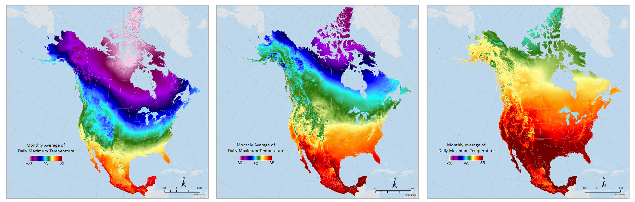
Daymet climatologies allow easy comparison of metrics like these monthly averages of maximum temperature for (left to right) January, April and August of 2019.
The widely used Daymet dataset of North American weather metrics has been upgraded with the release of Daymet Version 4, rolling out enhancements such as greater precision on temperatures and time-of-observation reporting.
Scientists in fields from hydrology to climate and crop modeling to biodiversity research can access the new data through the Oak Ridge National Laboratory Distributed Active Archive Center (ORNL DAAC), which houses terrestrial ecology data from NASA Earth Science missions.
Daymet provides data for seven daily weather parameters for each square kilometer of the continent, stretching from Canada to Mexico and Puerto Rico to Hawaii. The dataset extends back to 1980, encompassing approximately 500 million data points for each year in the series. It is generated with observations from 20,000 National Oceanic and Atmospheric Administration stations combined with modeled values for metrics such as shortwave radiation, using an algorithm to interpolate data for areas between stations.
Version 4 improves the precision of a range of measurements, including temperature, which was previously measured in half degree increments and is now recorded to the hundredth of a degree. The Daymet team addressed a known bias in the sensors of high elevation weather stations and improved time-of-observation reporting for weather stations, interpolation in regions with fewer weather stations, and data captured during extreme precipitation events, such as hurricanes.
“These data provide the foundation for a lot of exciting science,” project lead Michele Thornton said. “We are continually examining ways to make the data and the tools for accessing it even better.”
The updates along with replicable validation processes are described in Nature Scientific Data.
Setting a gold standard
Among their many uses, these weather data help to inform and validate projections from Earth system models, which are often primed by focusing on historical data. Comparing model outputs to the actual data for specific time periods aids scientists in calibrating the models to better predict future global change.
Many of the recent Daymet updates were driven by a need for high quality data to help build and validate a version of the land model for the Department of Energy’s (DOE’s) Energy Exascale Earth System Model (E3SM) project that could serve as what ORNL’s Peter Thornton calls a “gold standard.” This means creating a high-resolution version of the land model that works at a 1 km scale across the continent and incorporates so much data that running it requires the power of ORNL’s Summit, the nation’s fastest supercomputer.
“Every model has its own biases, but a gold standard simulation would provide our best estimate of what the land model outputs look like with uncertainties minimized,” said Peter Thornton, who leads the Earth Systems Science Section. “It also allows us to compare these results with E3SM in its coupled configuration with land, atmosphere, and ocean simulations, which can help us improve future predictions of environmental change.”
ORNL’s work with E3SM and the associated updates to Daymet were funded by the Biological and Environmental Research program in DOE’s Office of Science. Daymet archiving and distribution are supported by NASA’s Earth Science Data and Information System (ESDIS) Project and Terrestrial Ecology Program.
UT-Battelle manages ORNL for the Department of Energy’s Office of Science, the single largest supporter of basic research in the physical sciences in the United States. The Office of Science is working to address some of the most pressing challenges of our time. For more information, please visit energy.gov/science.


