

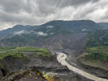
ORNL drone and geospatial team becomes first to map the Coca River in the Amazon basin as erosion and sediment threaten Ecuador’s lands.
Jack Orebaugh, a forensic anthropology major at the University of Tennessee, Knoxville, has a big heart for families with missing loved ones. When someone disappears in an area of dense vegetation, search and recovery efforts can be difficult, especially when a missing person’s last location is unknown. Recognizing the agony of not knowing what happened to a family or friend, Orebaugh decided to use his internship at the Department of Energy’s Oak Ridge National Laboratory to find better ways to search for lost and deceased people using cameras and drones.

Deep stores of carbon in northern peatlands may remain stable despite rising temperatures, according to a team of researchers from several U.S.-based institutions. And that is good news for now, the researchers said. Florida State University ...

Oak Ridge National Laboratory researchers have produced the next generation of the National Hydropower Map – a visualization tool that provides updated statistics on overall capacity and performance on the nation’s hydropower fleet. The map is part of the lab’s National Hydropower ...