![Sphere that has the top right fourth removed (exposed) Colors from left are orange, dark blue with orange dots, light blue with horizontal lines, then black. Inside the exposure is green and black with boxes.](/sites/default/files/styles/featured_square_large/public/2024-06/slicer.jpg?h=56311bf6&itok=bCZz09pJ)
Filter News
Area of Research
News Type
News Topics
- (-) 3-D Printing/Advanced Manufacturing (4)
- (-) Artificial Intelligence (2)
- (-) Big Data (3)
- (-) Coronavirus (7)
- (-) Transportation (4)
- Advanced Reactors (6)
- Bioenergy (1)
- Biology (3)
- Biomedical (9)
- Chemical Sciences (2)
- Climate Change (5)
- Computer Science (9)
- Energy Storage (9)
- Environment (10)
- Frontier (1)
- Fusion (5)
- Grid (4)
- Isotopes (2)
- Machine Learning (3)
- Materials Science (9)
- Mathematics (1)
- Microscopy (3)
- Molten Salt (1)
- Nanotechnology (3)
- Neutron Science (6)
- Nuclear Energy (9)
- Physics (7)
- Polymers (2)
- Security (1)
- Summit (5)
- Sustainable Energy (8)
Media Contacts
![Batteries - The 3D connection](/sites/default/files/styles/list_page_thumbnail/public/2020-05/Batteries_3D%20story%20tip_2.jpg?h=aeb34e32&itok=puhZ_584)
Oak Ridge National Laboratory researchers have developed a thin film, highly conductive solid-state electrolyte made of a polymer and ceramic-based composite for lithium metal batteries.
![GIS – LandScan goes public](/sites/default/files/styles/list_page_thumbnail/public/2020-05/sanfran%20%281%29_2.png?h=ea18fbc4&itok=c_VbFqAC)
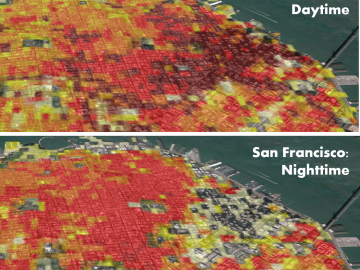
Oak Ridge National Laboratory’s high-resolution population distribution database, LandScan USA, became permanently available to researchers in time to aid the response to the novel coronavirus pandemic.
![Wireless charging – Special delivery for UPS](/sites/default/files/styles/list_page_thumbnail/public/2020-05/UPS_wireless_power_story%20tip_3000.jpg?h=3748d94f&itok=Xf2MDLEi)
Researchers at Oak Ridge National Laboratory demonstrated a 20-kilowatt bi-directional wireless charging system on a UPS plug-in hybrid electric delivery truck, advancing the technology to a larger class of vehicles and enabling a new energy storage method for fleet owners and their facilities.
![A new computational approach by ORNL can more quickly scan large-scale satellite images, such as these of Puerto Rico, for more accurate mapping of complex infrastructure like buildings. Credit: Maxar Technologies and Dalton Lunga/Oak Ridge National Laboratory, U.S. Dept. of Energy](/sites/default/files/styles/list_page_thumbnail/public/2020-02/Puerto_Rico_Resflow9.png?h=a0a1befd&itok=5n2fss_e)
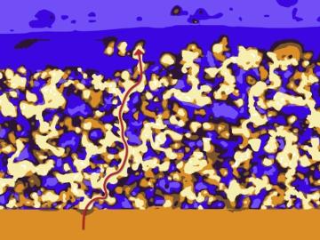
A novel approach developed by scientists at ORNL can scan massive datasets of large-scale satellite images to more accurately map infrastructure – such as buildings and roads – in hours versus days.
![Peter Wang](/sites/default/files/styles/list_page_thumbnail/public/2020-01/2019-P18026_0.jpg?h=8f9cfe54&itok=_gPTJOy-)
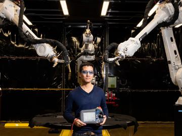
Peter Wang is focused on robotics and automation at the Department of Energy’s Manufacturing Demonstration Facility at ORNL, working on high-profile projects such as the MedUSA, a large-scale hybrid additive manufacturing machine.
![Dalton Lunga](/sites/default/files/styles/list_page_thumbnail/public/2020-01/Dalton_Lunga.jpg?h=4dcbbf6e&itok=0FQ-t5EF)
A typhoon strikes an island in the Pacific Ocean, downing power lines and cell towers. An earthquake hits a remote mountainous region, destroying structures and leaving no communication infrastructure behind.