![Sphere that has the top right fourth removed (exposed) Colors from left are orange, dark blue with orange dots, light blue with horizontal lines, then black. Inside the exposure is green and black with boxes.](/sites/default/files/styles/featured_square_large/public/2024-06/slicer.jpg?h=56311bf6&itok=bCZz09pJ)
Filter News
Area of Research
- (-) Biology and Environment (16)
- (-) Clean Energy (8)
- (-) Nuclear Science and Technology (1)
- Computational Engineering (2)
- Computer Science (2)
- Fusion and Fission (5)
- Fusion Energy (1)
- Materials (3)
- Materials for Computing (2)
- Mathematics (1)
- National Security (1)
- Neutron Science (2)
- Quantum information Science (3)
- Supercomputing (11)
News Topics
- (-) Bioenergy (12)
- (-) Climate Change (8)
- (-) Nuclear Energy (2)
- (-) Summit (2)
- 3-D Printing/Advanced Manufacturing (24)
- Advanced Reactors (1)
- Artificial Intelligence (2)
- Big Data (4)
- Biology (22)
- Biomedical (4)
- Biotechnology (5)
- Buildings (11)
- Chemical Sciences (1)
- Clean Water (6)
- Composites (5)
- Computer Science (6)
- Coronavirus (2)
- Critical Materials (3)
- Decarbonization (6)
- Energy Storage (20)
- Environment (34)
- Exascale Computing (1)
- Fusion (1)
- Grid (8)
- High-Performance Computing (7)
- Materials (19)
- Materials Science (7)
- Mathematics (1)
- Mercury (3)
- Microscopy (1)
- Nanotechnology (2)
- Net Zero (1)
- Neutron Science (3)
- Polymers (3)
- Security (1)
- Space Exploration (1)
- Statistics (1)
- Sustainable Energy (31)
- Transportation (16)
Media Contacts
![Urban climate modeling](/sites/default/files/styles/list_page_thumbnail/public/2021-03/urbanclimate_sized.jpeg?h=0d9d21a1&itok=-ICe9HqY)
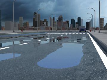
Researchers at Oak Ridge National Laboratory have identified a statistical relationship between the growth of cities and the spread of paved surfaces like roads and sidewalks. These impervious surfaces impede the flow of water into the ground, affecting the water cycle and, by extension, the climate.
![Permafrost](/sites/default/files/styles/list_page_thumbnail/public/2022-03/Permafrost%20Icon.png?h=46fc168e&itok=4HvF6HF1)
A study by Oak Ridge National Laboratory, the University of Copenhagen, the National Park Service and the U.S. Geological Survey showed that hotter summers and permafrost loss are causing colder water to flow into Arctic streams, which could impact sensitive fish and other wildlife.
![The TRITON model provides a detailed visualization of the flooding that resulted when Hurricane Harvey stalled over Houston for four days in 2017. Credit: Mario Morales-Hernández/ORNL, U.S. Dept. of Energy](/sites/default/files/styles/list_page_thumbnail/public/2021-01/TRITON%20screenshot.png?h=4a7d1ed4&itok=IEra5eDk)
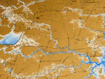
A new tool from Oak Ridge National Laboratory can help planners, emergency responders and scientists visualize how flood waters will spread for any scenario and terrain.