
Balaprakash chosen for Tennessee’s new AI advisory council
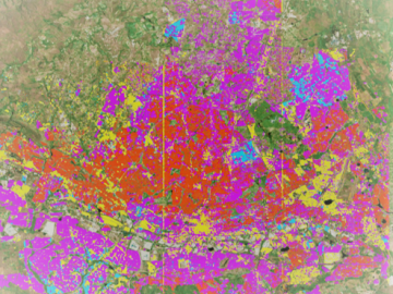
Geospatial scientists at Oak Ridge National Laboratory analyzed three cities of varying infrastructures to look for patterns of electricity use and locate “dark spots” where informal neighborhoods may lack access to power.
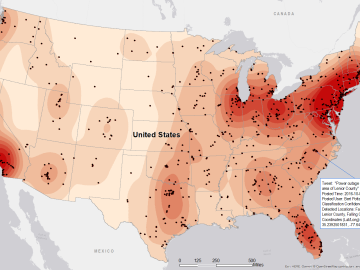
Gleaning valuable data from social platforms such as Twitter—particularly to map out critical location information during emergencies— has become more effective and efficient thanks to Oak Ridge National Laboratory.

Jennifer Ladd-Lively has been leading the Electrical Systems Engineering and Integration Group since September, bringing with her the organizational and time management skills learned through several years as a research scientist and project manager. The group she leads specializes in designing a...

Thought leaders from across the maritime community came together at Oak Ridge National Laboratory to explore the emerging new energy landscape for the maritime transportation system during the Ninth Annual Maritime Risk Symposium.
 Jeff Manning, Chris Zerr, Bruce Lester, Joe Pyle, Darrell Roddy and Rusty Dryman.")
Bruce Lester has had a lot of jobs: fisherman, horse trainer, “professional stair builder.” He last worked for a real estate company, surveying land using geographic software. “When the bottom fell out of the construction industry and the company downsized, I got laid off,”
Knoxville-based Fiveworx has licensed an Oak Ridge National Laboratory technology that will help consumers reduce their utility bills by analyzing their home energy usage.