![This photo is of a male scientist sitting at a desk working with materials, wearing protective glasses.](/sites/default/files/styles/featured_square_large/public/2024-07/2023-P08173.jpg?h=c6980913&itok=LnJLvflD)
Filter News
Area of Research
- (-) Advanced Manufacturing (5)
- (-) National Security (9)
- Biology and Environment (38)
- Building Technologies (2)
- Clean Energy (73)
- Computational Engineering (1)
- Computer Science (6)
- Electricity and Smart Grid (1)
- Energy Sciences (1)
- Functional Materials for Energy (1)
- Fusion and Fission (4)
- Fusion Energy (2)
- Materials (15)
- Materials for Computing (5)
- Neutron Science (4)
- Nuclear Science and Technology (1)
- Quantum information Science (1)
- Supercomputing (28)
News Topics
- (-) Big Data (6)
- (-) Sustainable Energy (8)
- 3-D Printing/Advanced Manufacturing (24)
- Advanced Reactors (2)
- Artificial Intelligence (13)
- Bioenergy (4)
- Biology (5)
- Biomedical (2)
- Biotechnology (1)
- Buildings (1)
- Chemical Sciences (2)
- Climate Change (5)
- Composites (3)
- Computer Science (20)
- Coronavirus (2)
- Cybersecurity (20)
- Decarbonization (2)
- Energy Storage (2)
- Environment (5)
- Exascale Computing (1)
- Frontier (1)
- Fusion (2)
- Grid (6)
- High-Performance Computing (4)
- Machine Learning (13)
- Materials (8)
- Materials Science (8)
- Nanotechnology (1)
- National Security (34)
- Neutron Science (6)
- Nuclear Energy (7)
- Partnerships (5)
- Physics (1)
- Quantum Science (1)
- Security (11)
- Simulation (1)
- Space Exploration (1)
- Summit (2)
- Transformational Challenge Reactor (1)
- Transportation (2)
Media Contacts
![A new computational approach by ORNL can more quickly scan large-scale satellite images, such as these of Puerto Rico, for more accurate mapping of complex infrastructure like buildings. Credit: Maxar Technologies and Dalton Lunga/Oak Ridge National Laboratory, U.S. Dept. of Energy](/sites/default/files/styles/list_page_thumbnail/public/2020-02/Puerto_Rico_Resflow9.png?h=a0a1befd&itok=5n2fss_e)
A novel approach developed by scientists at ORNL can scan massive datasets of large-scale satellite images to more accurately map infrastructure – such as buildings and roads – in hours versus days.
![Smart Neighborhood homes](/sites/default/files/styles/list_page_thumbnail/public/2020-01/04.09.TD-SMartHome_0.jpg?h=5b5a5437&itok=22S5Tle1)
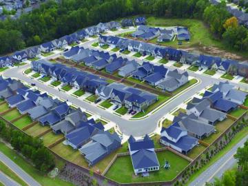
To better determine the potential energy cost savings among connected homes, researchers at Oak Ridge National Laboratory developed a computer simulation to more accurately compare energy use on similar weather days.
![CellSight allows for rapid mass spectrometry of individual cells. Credit: John Cahill, Oak Ridge National Laboratory/U.S. Dept of Energy](/sites/default/files/styles/list_page_thumbnail/public/2019-10/4CellSightPhoto_0.png?h=67debf3e&itok=fmsxiN_b)
Researchers at the Department of Energy’s Oak Ridge National Laboratory have received five 2019 R&D 100 Awards, increasing the lab’s total to 221 since the award’s inception in 1963.
![As part of a preliminary study, ORNL scientists used critical location data collected from Twitter to map the location of certain power outages across the United States.](/sites/default/files/styles/list_page_thumbnail/public/2019-02/PowerOutageTweets_map_0.png?h=6448fdc1&itok=AUit-O2Y)
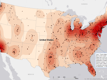
Gleaning valuable data from social platforms such as Twitter—particularly to map out critical location information during emergencies— has become more effective and efficient thanks to Oak Ridge National Laboratory.