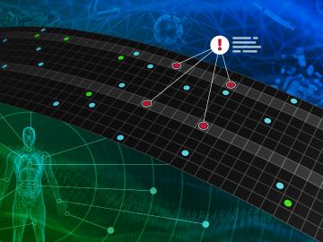
![Sphere that has the top right fourth removed (exposed) Colors from left are orange, dark blue with orange dots, light blue with horizontal lines, then black. Inside the exposure is green and black with boxes.](/sites/default/files/styles/featured_square_large/public/2024-06/slicer.jpg?h=56311bf6&itok=bCZz09pJ)
Filter News
Area of Research
- (-) National Security (17)
- Advanced Manufacturing (8)
- Biological Systems (1)
- Biology and Environment (128)
- Biology and Soft Matter (1)
- Building Technologies (2)
- Clean Energy (168)
- Climate and Environmental Systems (5)
- Computational Biology (2)
- Computational Engineering (2)
- Computer Science (5)
- Electricity and Smart Grid (3)
- Energy Sciences (1)
- Functional Materials for Energy (2)
- Fusion and Fission (7)
- Fusion Energy (3)
- Isotopes (8)
- Materials (102)
- Materials Characterization (2)
- Materials for Computing (16)
- Materials Under Extremes (1)
- Mathematics (1)
- Neutron Science (38)
- Nuclear Science and Technology (4)
- Quantum information Science (2)
- Sensors and Controls (1)
- Supercomputing (92)
News Topics
- (-) Biomedical (2)
- (-) Environment (5)
- (-) Grid (6)
- (-) Materials (2)
- (-) Summit (2)
- (-) Sustainable Energy (3)
- 3-D Printing/Advanced Manufacturing (2)
- Advanced Reactors (1)
- Artificial Intelligence (12)
- Big Data (6)
- Bioenergy (3)
- Biology (5)
- Biotechnology (1)
- Buildings (1)
- Chemical Sciences (2)
- Climate Change (5)
- Computer Science (19)
- Coronavirus (2)
- Cybersecurity (19)
- Decarbonization (2)
- Energy Storage (2)
- Exascale Computing (1)
- Frontier (1)
- Fusion (1)
- High-Performance Computing (4)
- Machine Learning (12)
- Materials Science (3)
- Nanotechnology (1)
- National Security (34)
- Neutron Science (4)
- Nuclear Energy (5)
- Partnerships (4)
- Physics (1)
- Quantum Science (1)
- Security (11)
- Simulation (1)
- Transportation (2)
Media Contacts
![ORNL, VA and Harvard researchers developed a sparse matrix full of anonymized information on what is thought to be the largest cohort of healthcare data used for this type of research in the U.S. The matrix can be probed with different methods, such as KESER, to gain new insights into human health. Credit: Nathan Armistead/ORNL, U.S. Dept. of Energy](/sites/default/files/styles/list_page_thumbnail/public/2022-04/2022-G00330_KESER%20Illustration_0.jpg?h=1cb48fc4&itok=c6ZuDdDg)
A team of researchers has developed a novel, machine learning–based technique to explore and identify relationships among medical concepts using electronic health record data across multiple healthcare providers.
![Earth Day](/sites/default/files/styles/list_page_thumbnail/public/2022-04/Earth%20image.png?h=8f74817f&itok=5rQ_su9Z)
Tackling the climate crisis and achieving an equitable clean energy future are among the biggest challenges of our time.
![ORNL research scientist Christa Brelsford explained a mathematical framework she developed in 2018, which showed increased availability of infrastructure didn’t necessarily reduce inequality in its access. Credit: Carlos Jones/ORNL, U.S. Dept. of Energy](/sites/default/files/styles/list_page_thumbnail/public/2022-04/image001.jpg?h=1579b22a&itok=XzIna_Uc)
Unequal access to modern infrastructure is a feature of growing cities, according to a study published this week in the Proceedings of the National Academy of Sciences
![ORNL Image](/sites/default/files/styles/list_page_thumbnail/public/SE_elec_consumption_withPplants.jpg?h=50ec1d8e&itok=SqxQDFw8)
An analysis published in the Proceedings of the National Academy of Sciences and led by researchers from the U.S. Department of Energy’s Oak Ridge National Laboratory has received the 2021 Sustainability Science Award from the Ecological Society of America.
![A new computational approach by ORNL can more quickly scan large-scale satellite images, such as these of Puerto Rico, for more accurate mapping of complex infrastructure like buildings. Credit: Maxar Technologies and Dalton Lunga/Oak Ridge National Laboratory, U.S. Dept. of Energy](/sites/default/files/styles/list_page_thumbnail/public/2020-02/Puerto_Rico_Resflow9.png?h=a0a1befd&itok=5n2fss_e)
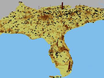
A novel approach developed by scientists at ORNL can scan massive datasets of large-scale satellite images to more accurately map infrastructure – such as buildings and roads – in hours versus days.
![Smart Neighborhood homes](/sites/default/files/styles/list_page_thumbnail/public/2020-01/04.09.TD-SMartHome_0.jpg?h=5b5a5437&itok=22S5Tle1)
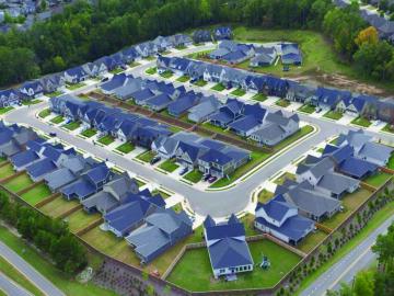
To better determine the potential energy cost savings among connected homes, researchers at Oak Ridge National Laboratory developed a computer simulation to more accurately compare energy use on similar weather days.
![As part of a preliminary study, ORNL scientists used critical location data collected from Twitter to map the location of certain power outages across the United States.](/sites/default/files/styles/list_page_thumbnail/public/2019-02/PowerOutageTweets_map_0.png?h=6448fdc1&itok=AUit-O2Y)
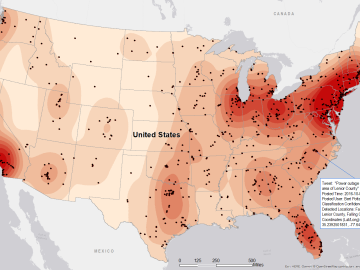
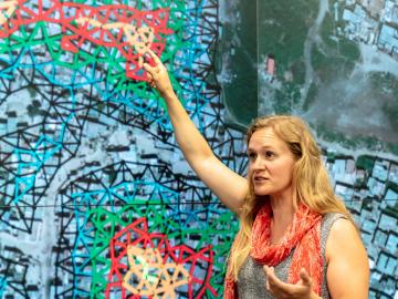
Gleaning valuable data from social platforms such as Twitter—particularly to map out critical location information during emergencies— has become more effective and efficient thanks to Oak Ridge National Laboratory.