ORNL researchers combined additive manufacturing with conventional compression molding to produce high-performance thermoplastic composites, demonstrating the potential for the use of large-scale multimaterial preforms to create molded composites. Credit: ORNL/U.S. Dept. of Energy

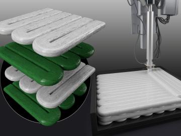
Oak Ridge National Laboratory researchers combined additive manufacturing with conventional compression molding to produce high-performance thermoplastic composites reinforced with short carbon fibers.

Verónica Melesse Vergara speaks with third and fourth graders at East Side Intermediate School in Brownsville. Credit: ORNL, U.S. Dept. of Energy

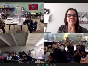
Twenty-seven ORNL researchers Zoomed into 11 middle schools across Tennessee during the annual Engineers Week in February. East Tennessee schools throughout Oak Ridge and Roane, Sevier, Blount and Loudon counties participated, with three West Tennessee schools joining in.

The ORNL National Center for Computational Sciences is now home two Hewlett Packard Enterprise, or HPE, Cray EX supercomputers that will provide the U.S. Army and Air Force with global and regional numerical weather model outputs for planning and executing missions worldwide. Credit: Jason Smith/ORNL, U.S. Dept. of Energy and HPE Cray

The U.S. Air Force and Oak Ridge National Laboratory launched a new high-performance weather forecasting computer system that will provide a platform for some of the most advanced weather modeling in the world.

The TRITON model provides a detailed visualization of the flooding that resulted when Hurricane Harvey stalled over Houston for four days in 2017. Credit: Mario Morales-Hernández/ORNL, U.S. Dept. of Energy

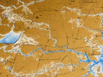
A new tool from Oak Ridge National Laboratory can help planners, emergency responders and scientists visualize how flood waters will spread for any scenario and terrain.

Diverse evidence shows that plants and soil will likely capture and hold more carbon in response to increasing levels of carbon dioxide in the atmosphere, according to an analysis published by an international research team led by Oak Ridge National Laboratory.

Diverse evidence shows that plants and soil will likely capture and hold more carbon in response to increasing levels of carbon dioxide in the atmosphere, according to an analysis

The hybrid inverter developed by ORNL is an intelligent power electronic inverter platform that can connect locally sited energy resources such as solar panels, energy storage and electric vehicles and interact efficiently with the utility power grid. Credit: Carlos Jones, ORNL/U.S. Dept of Energy.

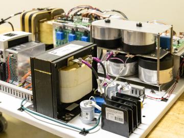
ORNL researchers have developed an intelligent power electronic inverter platform that can connect locally sited energy resources such as solar panels, energy storage and electric vehicles and smoothly interact with the utility power grid.

The CrossVis application includes a parallel coordinates plot (left), a tiled image view (right) and other interactive data views. Credit: Chad Steed/Oak Ridge National Laboratory, U.S. Dept. of Energy

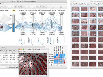
From materials science and earth system modeling to quantum information science and cybersecurity, experts in many fields run simulations and conduct experiments to collect the abundance of data necessary for scientific progress.

Pine trees in the Tuolumne Valley of Yosemite National Park show the effects of drought and fire. Credit: Anthony Walker/Oak Ridge National Laboratory, U.S. Dept. of Energy

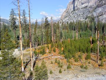
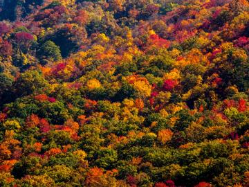
A multi-institutional research team found that changing environmental conditions are affecting forests around the globe, leading to increasing tree death and uncertainty about the ability of forests to recover.

Nuclear – Finally, a benchmark

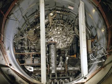
In the 1960s, Oak Ridge National Laboratory's four-year Molten Salt Reactor Experiment tested the viability of liquid fuel reactors for commercial power generation. Results from that historic experiment recently became the basis for the first-ever molten salt reactor benchmark.

A new computational approach by ORNL can more quickly scan large-scale satellite images, such as these of Puerto Rico, for more accurate mapping of complex infrastructure like buildings. Credit: Maxar Technologies and Dalton Lunga/Oak Ridge National Laboratory, U.S. Dept. of Energy

A novel approach developed by scientists at ORNL can scan massive datasets of large-scale satellite images to more accurately map infrastructure – such as buildings and roads – in hours versus days.